About Earthscapes
River Deltas- Lena Delta

Deltas are the unsung heroes of our Planet, fertilizing hundreds of thousands of miles across our Earth as they distribute sediment from Rivers to the shorelines.
Deltas are accumulations of sediment at River mouths. The term 'Delta' is derived from the Greek letter 'Delta', which in its capital form is triangular, a common shape of river Deltas, such as the Nile.
One in 15 of the world's Population lives, breathes and works on one of the 40 or so Major Deltas on Planet Earth.
Deltas offer a wide range of environments, including valuable wetlands that provide significant ecosystems.
They also provide many resources for Human Populations, including fertile land for agriculture and access to fishing.
From Space, these vast areas look like branching blood vessels, crossing entire continents until they reach the Sea.
In fact, only when viewed from above is it possible to appreciate their scale and the impact they have on shaping our land - and how beautiful they are.
Like the Tree of Life: The Lena Delta in Siberia covers 61,000 square kilometers of land, with the Delta about 30,000 square kilometers - one of the largest in the world.
River Systems - Mayn River

Rivers are vital but also complex and dynamic systems. Incised across continents, River systems are a key component of the Planet’s circulatory system, acting much like veins in our bodies pumping freshwater to Wetlands, Lakes and out to Sea.
Like the blood in veins, River water also transports a variety of chemical compounds, from nutrients to waste products. They flush nutrients through aquatic ecosystems, keeping thousands of species alive, and help sustain vital fisheries. As veins deliver blood back to the heart, Rivers carry water through watershed lands back to the Sea. Through various Seasons—Winter and Summer, Rainy and Dry—River flows rise and fall, like a Planetary Pulse.
Civilization has always had an intimate relationship with Rivers. They provide drinkable water, habitable areas, transportation, communication routes, food, power, and constantly replenish agricultural land. They connect us to Deltas and to Coastal Marine systems; they carve their way through the land and are the ribbon of life in dry and wet communities.
An unsettling number of large Rivers—including the Colorado, Rio Grande, Yellow, Indus, Ganges, Amu Darya, Murray, and Nile—are now so over-tapped that they discharge little or no water to the Sea for months at a time.
The Mayn River meets the Anadyr at Ust-Maynin the mid-lower stretch of its course, in an area of wetlands and small lakes. Flowing roughly northwards from its source in the small Mainskoe Lake, this River passes through sparsely populated areas of the forest-tundra subzones of Eastern Siberia. This River is frozen for about eight to nine months in a year.
Coastal Zones- Kamchatka Peninsula

Some of the most productive and biologically rich areas on Earth, the Coastal Zones make up only 10% of the Ocean environment, but are home to over 90% of all Marine Species. The Coastal zone has the most nutrients of all marine environments. As a result, a number of extremely productive and complex coastal ecosystems have evolved. They support a huge variety of life, many also serve as nurseries for much of the biodiversity of the entire oceanic system.
Oceans are the lifeblood of planet Earth and humankind. They cover nearly three-quarters of our planet, hold 97% of the planet's water, and are estimated to produce more than half of the oxygen in the atmosphere. Ocean waters have the capacity to absorb vast amounts of the greenhouse-warming gas carbon dioxide and in general act as a regulator of temperature and weather. They are also an integral part of the water cycle. Vast amounts of water evaporate from the ocean surface, rising into the atmosphere as water vapor. When this vapor collides with colder air, it condenses to form clouds and rain.
The coast also has a huge influence on people. According to the UN, around 3.6 billion people, or 60% of the world’s population, live within 60km of the coast. Most of the goods we extract from the ocean - from fish to oil and gas - come from coastal regions. But the world’s oceans, seas and coasts are under severe strain. The biggest threats right now are overfishing, climate change and pollution.
The Kamchatka Peninsula is in far North Eastern Russia, lying between the Sea of Okhotsk on the west and the Pacific Ocean and Bering Sea on the east. Kamchatka boasts diverse and abundant wildlife and a very low human population. Cold arctic winds from Siberia combined with the cold Ovashio sea current see it covered in snow from October to late May. Since it lies on the Pacific Rim of Fire, the peninsula has a high density of volcanoes, with many of them active. Because of this, Kamchatka is also known as "The Land of Fire and Ice".
Deserts- Dasht-e Kavir

Far from being barren wastelands, deserts are biologically rich habitats with a vast array of animals and plants that have adapted to the harsh conditions there. Some deserts are among the planet's last remaining areas of total wilderness. Desert animals have developed ways to help them keep cool and minimize water use. Many desert animals are nocturnal, coming out only when the brutal sun has descended to hunt. Desert plants may have to go without fresh water for years at a time. Many of these plants have special means of collecting, storing and conserving water. Deserts receive little rainfall, however, when rain does fall, the desert experiences a short period of great abundance.
More than one billion people, one-sixth of the Earth's population, actually live in desert regions. People have struggled to live in deserts and the surrounding semi-arid lands for millennia. Nomads have moved their flocks and herds to wherever grazing is available and oases have provided opportunities for a more settled way of life. Desert Farming is possible with the aid of irrigation from rivers or wells.
Some of the world's semi-arid regions are turning into desert at an alarming rate. This process, known as "desertification," is not caused by drought, but usually arises from the demands of human populations that settle on the semi-arid lands to grow crops and graze animals.
Dasht-e Kavir, also known as the Great Salt Desert is a large desert lying in the middle of the Iranian plateau. It is about 500 mi by 200 mi with a total surface area of about 30,000 sq mi.
The desert receives little water each year. However, the surrounding mountains on all sides, provide plenty of runoff to create vast seasonal lakes, rivers, marshlands and playas. The hot temperatures cause extreme vaporization, which leaves the marshes and mud grounds with large crusts of salt. Temperatures can reach 50 °C (122 °F) in summer, and day and night temperatures can differ up to 70 °C (158 °F). Heavy storms frequently occur and they can cause sand hills reaching up to 140ft in height. The extreme heat and many storms in Dasht-e Kavir cause extensive erosion, which makes it almost impossible to cultivate the lands. The desert is almost uninhabited and knows little exploitation.
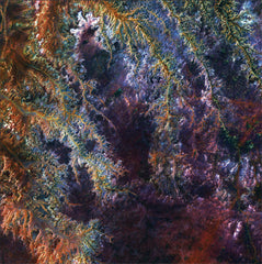
Mountains- The Atlas

Mountains are the highest points on Earth and some of the most dynamic land forms on our planet. They rise up as the crust collides, cracks, crumbles, folds, and spews. Over time, they erode back into the plains or seas. The world's tallest mountain ranges form when pieces of Earth's crust—called plates—smash against each other, in a process called plate tectonics, and buckle up like the hood of a car in a head-on collision.
Mountains often serve as geographic features that define natural borders of countries. Their height can influence weather patterns, stalling storms that roll off the oceans and squeezing water from the clouds. As a result, one side is often much drier than the other.
Mountains are generally less preferable for human habitation than lowlands, because of harsh weather and little level ground suitable for agriculture. However, this inaccessibility has often served to protect and preserve local cultures and traditions from outside invaders. About half of mountain dwellers live in the Andes, Central Asia, and Africa.
The images we are printing are from the Anti-Atlas Mountains, part of the Atlas Mountain range in southern Morocco, Africa. These mountains were formed when Africa and America collided, and were once a chain rivaling today's Himalayas. The Atlas range stretches around 1,600 mi through Algeria, Morocco and Tunisia. It separates the Mediterranean and Atlantic coastlines from the Sahara Desert. The range's highest peak is Jebel Toubkal, with an elevation of 13,671 ft.
The Anti-Atlas is a desolate world of rocky outcrops and lunar landscapes where the contrasts are extreme. Most of the land is dry and barren, but water gathers and runs in some remote places, forming clear basins. Villages in the area are limited to a few small houses surrounded by palm trees. The mountains are home to a number of plant and animal species unique in Africa, often more like those of Europe.